If you thought those super-precise 2D satellite images of—for example—bombed-out Iranian nuclear sites were cool, just wait ’til you hear what Vantor has in store for you today.
This morning, the satellite imaging company (formerly known as Maxar Intelligence—but you should know that by now) released a new product line it’s calling WorldView 3D that lets “mapmakers, intelligence analysts, and tactical operators refresh 3D terrain from space on command” super-fast and in super-high def.
The capability basically means that WorldView users get highly accurate 3D maps in record time, which is helpful for everything from drone navigation (remember Raptor?), to mission planning, to things like the US Army’s mixed-reality combat system (Vantor teamed up with Anduril on that one last year).
The product will be available to users on Vantor Hub (cute) in early July.
Eye in the sky: We covered Vantor last week, so y’all won’t need too much context, but here’s a refresher on the geospatial intelligence big dog:
- The company operates one of the largest Earth observation satellite networks—including a ton of WorldView satellites inherited from its predecessor, Maxar.
- But it’s not just satellites—the company combines satellite imagery, AI, and software to help governments and commercial customers understand what’s happening on the ground.
- Its flagship software platform, Tensorglobe, fuses data from satellites, drones, aircraft, and ground sensors into a single common operating picture.
- They also use all that geospatial data for 3D mapping—their Raptor Alternative Positioning, Navigation, and Timing (AltPNT) software (unveiled last year) helps automated systems navigate without GPS.
- WorldView (the OG version) is Vantor’s imagery-as-a-service platform—basically the front end through which governments and commercial customers request and receive optical, radar, and orbital imagery on demand.
The new WorldView products are basically 3D mapping on steroids. Like all of Vantor’s products, WorldView 3D benefits from decades—like, many decades—of satellite imagery and combos it with “proprietary fusion and processing techniques” (read: nifty software and AI) to create 3D representations of Earth.
[This] is a product line that’s designed to be a taskable product,” Vantor CPO Peter Wilczynski told Tectonic. “Rather than [just] harvesting data from the last 20 years that we’ve collected accidentally or based on other requirements, this is really allowing the constellation to start producing data on demand.”
WorldView 3D comes in 2 different flavors:
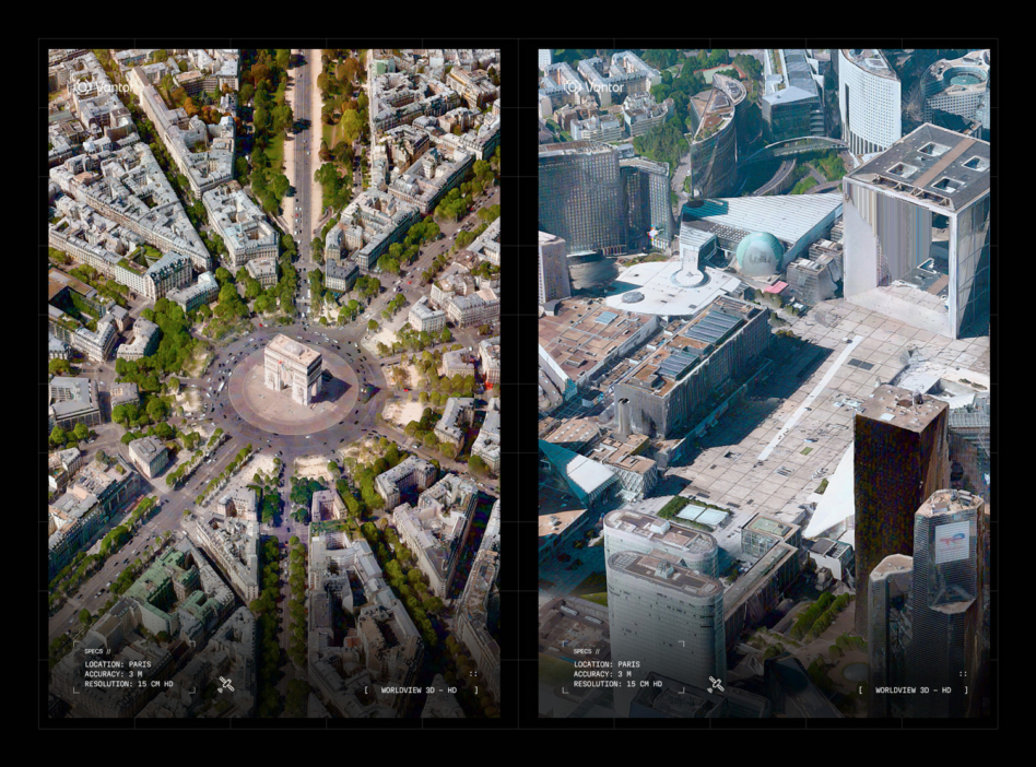
- WorldView 3D Rapid: This is the express checkout lane of Vantor 3D mapping. This offers “refreshable 3D terrain within 24 hours of collection” (fast!) with 50 cm-class resolution and 4m accuracy. The company says it’s designed for “time-sensitive missions like rapid mapping, intelligence analysis, and tactical operations.” Basically, anything where you need to be speedy quick.
- WorldView 3D HD: This is the ultra HD version of WorldView 3D. It delivers 15 cm resolution and 3m accuracy, but isn’t quite as quick as the Rapid version. However, Vantor says it has “refresh subscriptions” that can keep the data current over time.
Traditionally, these kinds of super-detailed 3D maps require drones and other (fairly pricey) ISR capabilities (like planes). Vantor says this is “the world’s first high-definition 3D maps produced from space-based imagery.”
Layer cake: Now, you might be wondering (as we were), “How exactly is Vantor doing this, and why hasn’t anyone else done it before?” Well, we’ve got answers.
Wilczynski described it as—essentially—a layered approach.
- Because of the immense amount of data Vantor already has, they’ve got a pretty accurate and reliable existing 3D map of the earth. Per the company, they’ve “mapped more than 100 million square kilometers of the world in 3 m-accurate 3D.” Let’s call this the base layer of the WorldView cake.
- But because they’ve also got so many satellites hovering around this lil’ planet we call home, they can also capture images of what’s happening here on earth pretty much anywhere, anytime. So users can be like, “Hey Vantor, tell me what’s happening in Kandahar,” and collect some current imagery.
- They then layer those images and data (within 24 hours, remember) on top of that existing map of the world to get up-to-date 3D representations of what’s happening on the ground. That’s the 3D intelligence frosting.
- The ultra-high-accuracy HD maps—taken and added in on demand—are the cherry on top.
- And the nice thing is, the more imagery is collected, the better Vantor’s 3D model of the world becomes.
As Wilczynski explained, this is not only super useful for mission planning and real-time intelligence—but also for things like drone navigation through Raptor.
- Before you launch a drone, you can refresh its 3D map (of a specific interest area) to make sure it has the most up-to-date model of an area on-mission.
- When the drone returns (for example, from a super-jammed area), the data and imagery it collected can then be fed back into WorldView to improve the accuracy of the map (and the functionality of things like Raptor).
“With WorldView 3D, customers can now update the specific areas they care about from space, with the speed, reach, and fidelity required for critical missions—all at a cost and scale that is competitive with aerial collection programs,” Wilczynski said in a statement. “This is how static 3D maps become living intelligence.”