Vantor’s satellite imagery just got a whole lot smarter with some help from their friends at a little startup called Google.
Yesterday, Vantor (the artist formerly known as Maxar Intelligence) announced a deal with Google to run Google’s Earth AI imagery models on Vantor’s government-focused, classified spatial intelligence platform, allowing Google’s AI to automate analysis reports for a whole lot of satellite imagery.
Sounds helpful—and complicated.
Imagine that: Under the deal, Google’s Earth AI model will run on Vantor’s spatial intelligence platform, called Tensorglobe.
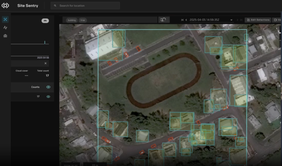
- Tensorglobe basically fuses data from satellites, ground assets, and drones into a high-fidelity digital twin of Earth accessible on Vantor’s Sentry platform. Tensorglobe also enables automated tasking of Vantor’s satellite constellation.
- Google’s Earth AI, for its part, is trained on massive datasets of satellite and aerial imagery to map and analyze buildings, roads, vessels, and whatever else government users want to keep an eye on.
- With the combo deal, Earth AI will be able to analyze Vantor’s classified satellite imagery on air-gapped networks in government data centers to produce automated intelligence analysis reports based on changes identified in imagery and news reports in areas of interest, rather than ChatGPT-style user prompts.
Satellite superpower: Put simply, the Earth AI model, running on Vantor’s imagery and 2D and 3D mapping data, will produce automated analytical reports within 15 minutes, rather than hours or days. It’ll also let Vantor hone and retrain the model using government data without exposing it to commercial networks.
“We’ve been focused on analyzing single images at a time,” Vantor’s Chief Product Officer Peter Wilczynski told Tectonic. “The real shift that this partnership represents is analyzing full stacks of imagery, translating that from pixels into text, and then applying reasoning to that text to close the loop for collection management.”
“The holy grail of what we’re building out with the Tensorglobe platform is the ability to have a fully closed-loop system that is collecting, producing, disseminating, and making decisions on data to drive collection,” he added. “That’s what [this partnership] with Google is allowing us to do.”
Ultimately, Vantor’s Tensorglobe platform will allow its satellite constellation to task and schedule imagery collection based on the reports generated by Earth AI.
“As a human, looking at the whole world at once is impossible—we need to zoom into the map and zoom out of the map. These AI systems don’t,” Wilczynski said. “They can look at the whole world at one time.”