Things keep getting busier and busier in Vantor-land.
On the heels of a deal to integrate with Google’s high-powered Earth AI model, the geospatial intelligence heavyweight announced a big ol’ follow-on contract with the US Army worth up to $217M to continue work on the service’s One World Terrain program, designed to “train and rehearse missions using high-precision, immersive 3D terrain.”
As Payload readers will know, Vantor (which rebranded from Maxar Intelligence last year) is a big deal in the satellite imagery world. Building on that vast geospatial data intelligence repository, the company has also become a power player in developing 3D representations and digital twins of the real world. Naturally, the Pentagon’s taken an interest in that capability.
Reality check: Since 2019, Vantor’s been providing data for the Army’s One World Terrain (OWT) program, the cornerstone of the service’s broader Synthetic Training Environment (STE) concept:
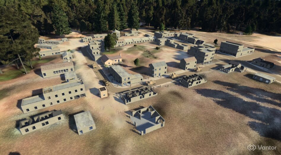
- Put simply, OWT aims to build a next-gen 3D geospatial database and virtual representation of the physical Earth for modeling and simulation hardware and training software.
- It runs on Vantor’s Vivid Terrain platform, which uses their Forge data-fusion software to continuously ingest and fuse data from satellites and drones to create a precise and up-to-date digital twin of the planet.
- That’s used to facilitate mission rehearsal and execution by enabling Army units to train in an immersive environment that reflects the real-world terrain they are operating in. Soldiers can interact with it from either a desktop or through a head-mounted display.
- That synthetic environment is so precise that soldiers can “move around buildings and understand the locations of windows or doors, which can be updated based on our understanding of that particular environment,” Vantor’s GM of US Government Susanne Hake told Tectonic.
“This is critical to building realistic, operationally relevant training environments to help soldiers prepare as quickly and effectively for their operations, especially when you think about the kinds of modern operations that the Army is doing,” Hake added. “There are particular operations that demand precision, whether that’s long-range precision fires, synchronized maneuvering, or operating drones in different environments.”
Big bucks: Under the $217M follow-on OTA deal, a five-year contract with a base performance year and four option years, Vantor’s focused on expanding the capabilities they built in the first contract, including integrating more drone-collected imagery, supporting larger-scale training efforts, and bringing that terrain data into other virtual reality efforts, including Anduril’s EagleEye mixed-reality headset for the Army’s Soldier-Borne Mission Command program.
“This is something that Vantor is really only able to provide. We have that 3D terrain, but we integrate other data sources, like commercial satellite, airborne data, and drones, to build this texture-rich understanding of the world,” Hake said. “This contract really enables readiness at scale by training as you fight.”